WHAT IS EMS?
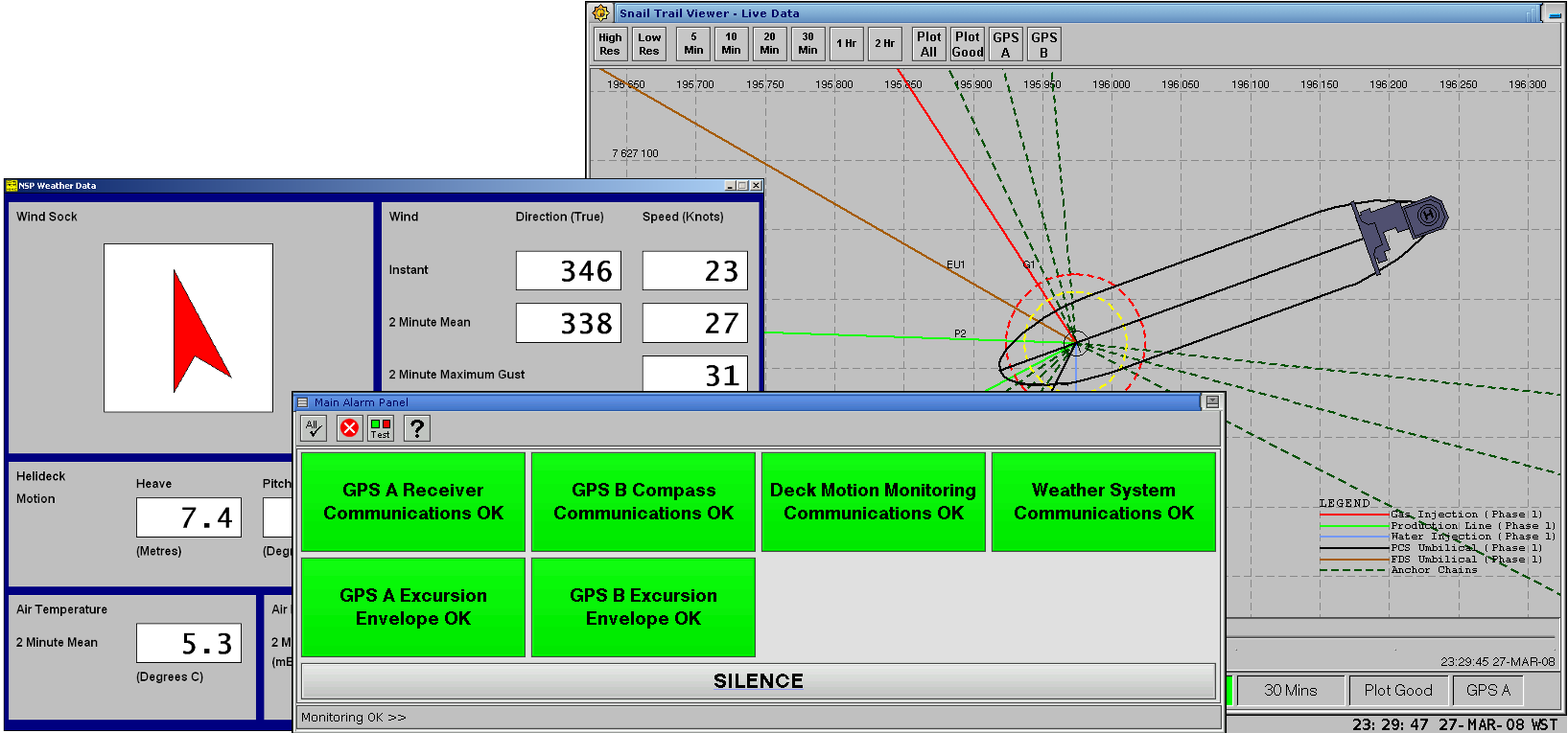
The Excursion Monitoring System, EMS, monitors the position of a floating vessel relative to its mooring centre and its excursion envelops. The position and orientation of the vessel is determined using data from DGPS receivers and a Motion Reference Unit, MRU. The system will generate an alarm to indicate a potential failure of the mooring system or an equipment failure.
The EMS provides both short-term and long-term position monitoring functions. The short-term function answers the question "where are we now?" and can be used to determine gross failure of the mooring system. The long-term function is used to determine partial failure of the mooring system which can cause a small offset in the vessel's position.
FEATURES AND BENEFITS
- Snail Trail Displays
- Roll and Pitch Compensation
- WGS84 to Local UTM Conversion
- Excursion Behaviour Modelling
- Dual Redundant Support
- Real Time Operating System
- High Reliability
- Low System Management
- Cost Effective
- Inner and Outer Excursion Alarm Limits
- Vendor-neutral Hardware
EMS APPLICATIONS
- Excursion / Movement Monitoring
- Position Reference
- Anchor-chain Intergrity Monitoring
- Weather System
- Data Server
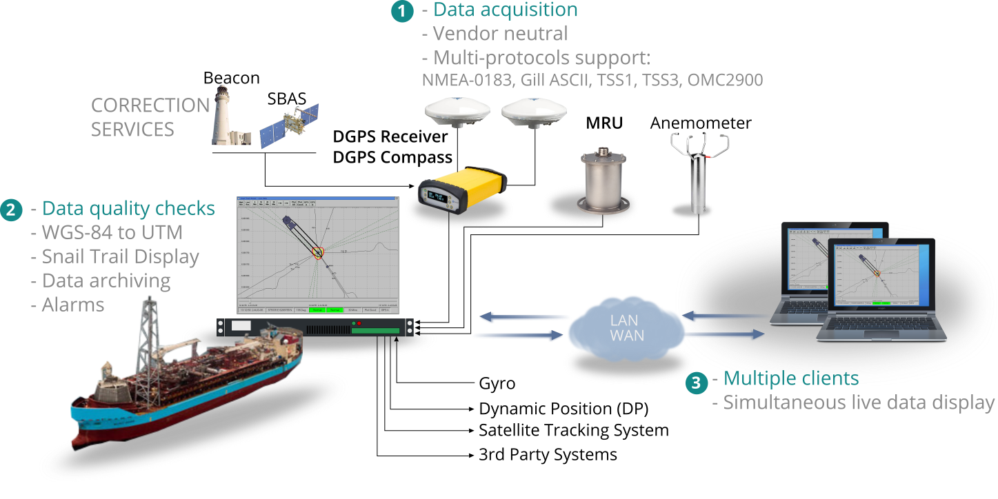
HOW IT WORKS
The EMS computer receives position and heading data from the DGPS receivers/compass and motion data from the MRU. The RUPEMS software running in the EMS computer processes the DGPS data and displays the vessel's position on a screen. The system monitors the position of the vessel and generates an alarm if the vessel's position moves out of the excursion envelopes.
Data Calculations
The EMS uses data from the DGPS receivers to compute the position of the vessel. The computation involves the following principal steps:
- Convert DGPS latitude and longitude from WGS84 to local UTM grid co-ordinates;
- Calculate the vessel's turret position while taking into account the vessel's heading, roll and pitch; and
- Determine the vessel's excursion status.
DGPS Performance and Accuracy
Most DGPS receiver vendors quote position accuracy better than 1 metre and heading accuracy better than 0.1 degrees. The accuracy of the vessel heading is vital for the EMS operations, hence, it is important to ensure good antenna locations while installing the DGPS antennas.
SPECIFICATIONS
All specifications provided are current at the time of publication. However, due to our continual product improvement policy, we reserve the right to make changes at any-time without notice. We also supply hardware to meet client's requirements.
HARDWARE
| Recommended GNSS Sensor |
|---|
| Make/Model: Trimble BX982 GNSS Receiver |
| Features: Supports GPS L1/L2/L5, GLONASS L1/L2/L3 and BeiDou B1, B2 signals. |
| EMS Computer |
|---|
| Shallow Depth 1U Rackmount Industrial Computer** |
| **We supply custom hardware to meet client's requirements. |
SOFTWARE
| Data Formats | |
|---|---|
| Message formats | NMEA-0183, Gill ASCII, TSS1, TSS3, OMC-2900 |
| NMEA Sentences | GGA, HDT and custom sentences. NOTE: Custom NMEA sentences can be supported as required. |
| Gill ASCII Formats | Mode 1, Mode 2 |
| TSS Formats | TSS1 Format, TSS3 Format |
| Modbus Protocols | Modbus ASCII/RTU/TCP, Modbus RTU over TCP |
| OPC | OPC support via Modbus servers |
| Others | NTP, SMTP, SNMP (versions 1,2,3), SSH |
USE CASES
SHELL CURLEW FPSO EXCURSION MONITORING SYSTEM, EMS
The Curlew FPSO and the Curlew wells are owned and operated by Shell. The producing reservoirs are tied back to the Curlew FPSO via subsea wells based around three drilling centres. All subsea tie-backs are part of the Gannet field.
The Curlew FPSO uses Excursion Monitoring System to monitors the position of the vessel. The current Curlew EMS was commissioned in 2014.
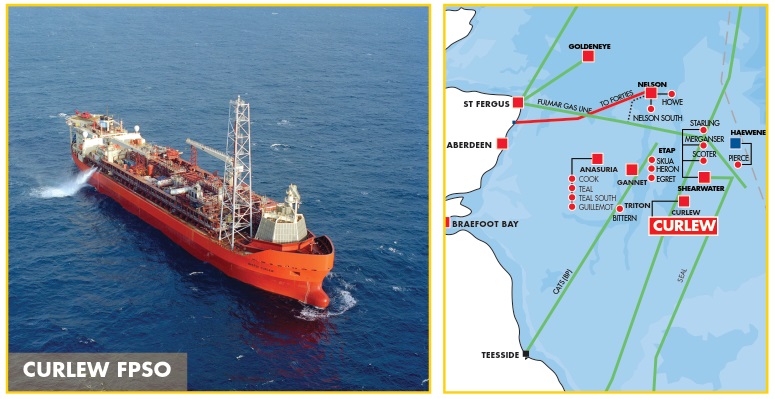 CURLEW FPSO (Source: Shell)
ICHTHYS CPF AND FPSO VESSEL EXCURSION SYSTEM, VES
Located about 220 kilometres offshore Western Australia, Ichthys represents the largest discovery of hydrocarbon liquids in Australia in 40 years. The Ichthys LNG Project is currently in construction (as at the date of this publication) and is ranked among the most significant oil and gas projects in the world.
Both the Ichthys CPF and Ichthys FPSO will use the VES to monitor the position of their individual mooring centres. The systems will be commissioned in 2016/17.
 ICHTHYS CPF & FPSO (Source: Inpex)
NGUJIMA-YIN FPSO EXCURSION MONITORING SYSTEM, EMS
The Ngujima-Yin FPSO is an offshore floating production, storage and offloading (FPSO) vessel operating in Commonwealth waters (Production Licence WA-28-L) about 43 kilometres north of the North West Cape, in northern Western Australia. Woodside purchased the Ngujima-Yin FPSO from Danish maritime company Maersk FPSOs in December 2011.
The Ngujima-Yin EMS monitors the position of the FPSO relative to its mooring centre and its excursion envelops. The position and orientation of the FPSO is determined using data from DGPS receivers and a Motion Reference Unit. The Ngujima-Yin EMS has been in use since 2008.
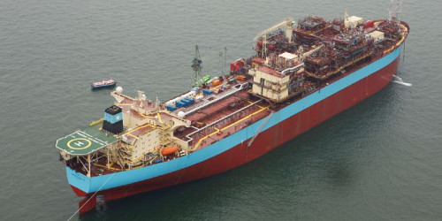 NGUJIMA-YI FPSO (Source: Oil Rig Photos)
HOW TO ORDER
We supply the Excursion Monitoring System directly to our customers. Please contact us with your requirements.
ORDERING OPTIONS
The EMS is available in a variety of configurations and options.
|
Remote Access Support Remote access support options: SSH, VPN (OpenVPN) and VNC over SSH tunnel. |
|
On-going Annual Support & Warranty Extension Covers technical queries, troubleshooting and software updates. Also includes hardware warranty extension for the life of the system. |
|
Onshore Data Server The onshore data server provides data archiving and display functions. This option helps in minimising data traffic over satellite links usually found in offshore applications. |
CONTACT
Address: Unit 16, Netherton Business Centre, Kemnay, Aberdeenshire, AB51 5LX, United Kingdom.
Website: www.rup.co.uk
Email: rup@rup.co.uk
Tel: +44 1467 642950
Software Development, Computer Systems, Consultancy Services
Copyright © 2016 RUP Limited. All rights reserved.